Tuesday, December 13, 2016

15 March 2016 - Western Illinois

15 March 2016


Initial Target: Peoria, IL
Final Target: Quincy, IL
Starting Point (SP): Midwest City, OK 1600 CDT 14 March 2016
Ending Point (ENDEX): Yukon, OK 1830 16 March 2016
Storm Intercepts: Quincy, IL; Carthage, IL; Adair, IL.
Tornadoes: 2
Hail: Quarter Size (1")
Wind: No direct measurement. Likely close to severe limits but uncomfirmed.
Miles: 1,517


Summary: Decided late the day before to make the trek to Illinois for one last chase before I started training for my Commercial Driver's License. Initially targeted Peoria and made it as far as the Northbound rest area on I-55 about 30 miles into Illinois. Woke up the next morning and looked at the surface observations and adjusted my target west to Quincy. This turned out to be a very good decision as I was in excellent position when the initial storms went up. Watched a cell try to lower itself just north of Quincy before heading north on IL-110. Saw a funnel far to my west when I was about halfway between Quincy and Carthage, but knew I would never get to it in time. I later found out it was the first tornado of the day, and that another chaser had verified ground contact. Intercepted my main storm just south of Carthage. Condensation funnel never made it to the ground, but I'm convinced that it was actually a tornado, due to the wind fields encountered at my position, and as I sliced north on the back side of the storm. Attempted to keep up with the storm on US-136, but was unable to, and broke on a cell to the south that was trying to root itself down. It had nice structure, but never got any serious rotation, so I headed east to Peoria and then started the journey home. Stopped for the night along the way and made it back to the OKC metro later that evening.

Crew: No chase partner

Equipment:
Vehicle: 2009 Nissan Titan SE 4x4
Camera: Canon Rebel XTi
Other Electronics: Dell Latitude E6430, Samsung Galaxy Grand Prime, Samsung Galaxy Note 4.


Map:


Details: A decent March setup had started to show up on the GFS about 10 days out, and I kept my eye on it as the time got closer. It never did look good from a moisture standpoint, but shear was good and CAPE was very good for the time of year. I had stopped at Old Chicago for a late lunch on the 14th and had my laptop with me as I looked over the models. My initial thought was to not drive that far for what had been seeming like a marginal setup, but I realized that it was likely my last chance to chase before I left in two weeks to train for my CDL. This turned out to be true, as the next chaseable setup was 2 weeks later, which was less than 96 hours after I had left home. So after some thinking about it, I decided to throw a few days worth of clothes in the pickup and take off up I-44. Thinking I was going to target Peoria, I stopped for the night at the northbound rest stop on I-55 about 30 miles into Illinois.

Waking up around 1000 on the 15th, I immediately noticed the strong south wind and knew I was south of the warm front. I looked at surface observations for the area as well as the visual satellite, and decided to set up in Quincy, which is about 90 miles further west than I had planned on, and in a less favorable area for both terrain and data. Stopped at a Love's to get cleaned up real quick (If you ever need a quick shower on the road and are not shelling out for hotel rooms, trucks stops generally have showers that are clean and provide fresh towels for $10-15), and arrived in Quincy around 1300. Stopped in a Best Buy parking lot to see if I needed to reposition, then found out a few chasers I know were already in Quincy (I'm assuming they saw my SN icon because I didn't know that's where they were targeting). Went over and met them at the Starbucks, because I'm not going to turn down a chance at coffee. By this point we were into the 70s as far as air temps went, and a cu field was slowly building overhead. It was now a waiting game.

Sometime after 1500 (I'm not 100% certain on the timing), the first towers started going up across the river on the Missouri side. Knowing storm motions would be what they were, I decided to wait on the Illinois side. I said my goodbyes and quickly got onto I-172 north out of Quincy, where I lost the freeway and it became IL-110 as a 4 lane divided highway.

Shortly north of where 172 became IL-110, I pulled off to the southbound side of the highway to watch a tower that was trying to get itself organized. I saw a few other chasers stop for a little while, but I remained patient as long as I could.


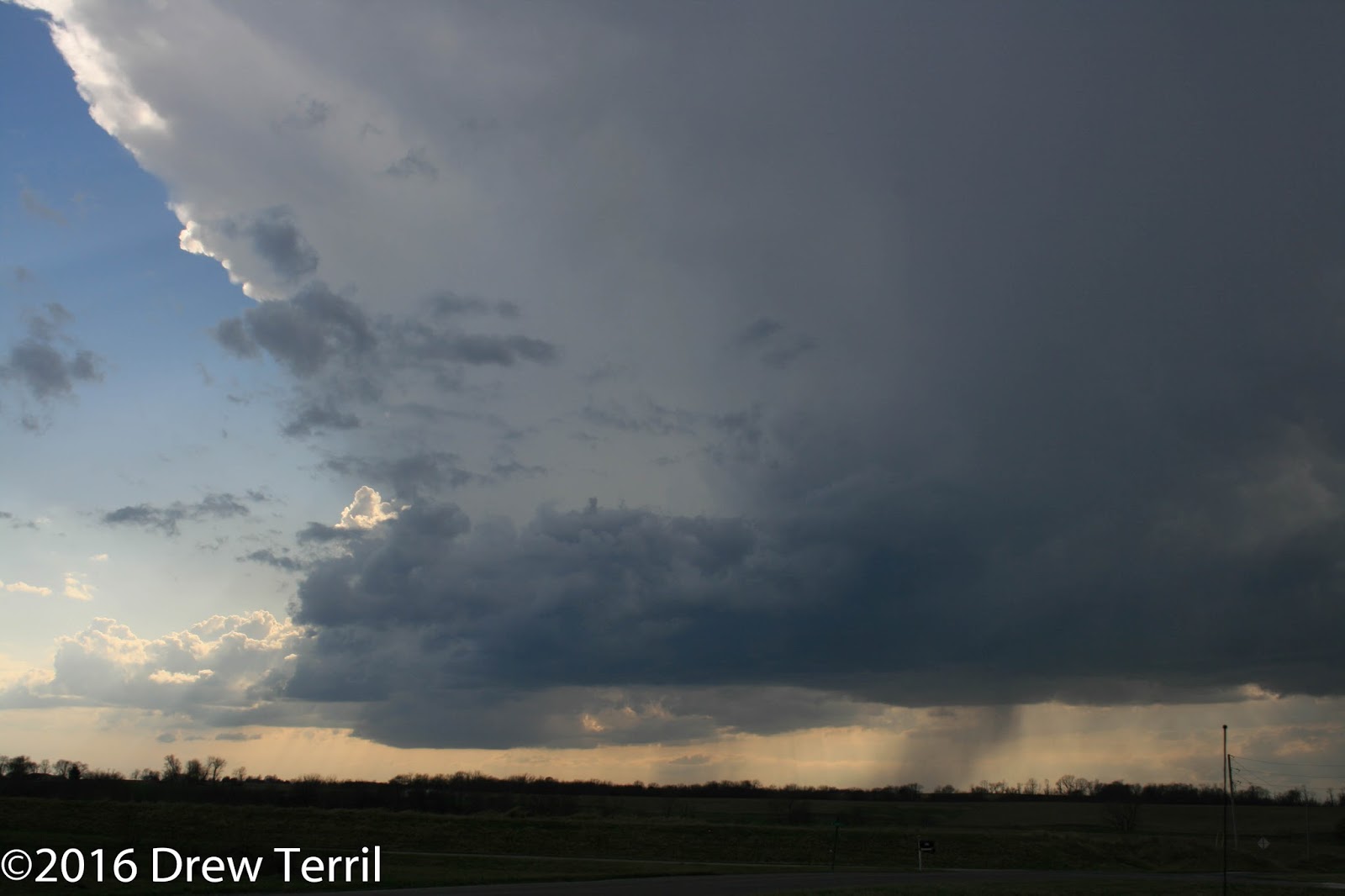
This one never could get itself together, so I finally gave up on it and drove north to intercept a cell that had pulled itself together and looked good on radar. Days like this make me realize that I need a dedicated dash cam, as this is the only shot I got rolling north on IL-110. I also lost all data shortly after leaving Quincy, and chased the majority of the day without said data.


Around the time I snapped that shot, I looked off to the west and saw what appeared to be a funnel off in the distance. I looked a little closer and there were actually two of them. My gut instinct told me I was on a tight timeline, so I pressed on and didn't take the time to stop and snap a picture. That said, I think it would have been outside of the capabilities of the camera equipment I had at the time.

Made it within a few miles of Carthage when I decided to pull off to the side of the road. I had a good view of the oncoming storm, and I was in a safe location to observe until the RFD overtook me.


Those were the best shots I had. This was an instance where I had wished I was running video equipment as well, and I would have been able to capture more of what was going on. Stills don't convey the pickup rocking from being blasted by inflow coming from the passenger side. Shortly after the last picture was taken, I pulled back to the south to avoid the bulk of the RFD. I still encountered what I would guess were 60-70mph winds, but I don't have an anemometer on my pickup, so I have no way of knowing for sure. I gave it enough time to know it would have crossed the road, then started slicing north up the hook towards US-136. Turned east on 136 and tried to catch back up with the storm but the hail had covered the roads so I kept my speed down and was unable to get back out in front of the storm. 

Made it to Macomb, where I finally regained data, and had a choice to make. Try to catch back up to the cell that, to this point, I had been unable to, but was already producing again, or cut east and south for a cell that was still trying to mature. I went for the latter, and continued east on US-136. The cell looked nice structurally, and I encountered my biggest hail of the day with this cell, but it never lost its elevated characteristics and never was able to pull together any rotation. I stopped to watch it near Adair, but it was getting dark and decided to head back for the interstates.

Continuing east on US-136 for a time, I picked up US-24 towards Peoria. The lightning show was impressive to my north, but I couldn't see much more than that due to the hills to my north blocking my view. I knew there was a tornado warning on the north side of Peoria, but, being in unfamiliar territory at night, I decided to head towards home and went south, narrowly getting past Springfield ahead of a squall line. From there I continued down I-55 to St. Louis where I picked up I-44 towards home, stopping to sleep at a rest area between Rolla and Springfield. I made it back home the next day after having covered just over 1500 miles.

After Action Review:

I made a good forecast, and adjusted it accordingly the morning of. When I lost data north of Quincy, I reverted back to the way I chased prior to 2012 where I relied primarily on instincts. This was a good final chase of the spring, as I missed the bulk of the season due to learning how to drive semi trucks.

Sustains and Improves: 

1. Keep up the forecasting work. I've made a lot of effort with my forecasting and it really paid off this season.
2. I need to incorporate video equipment into what I carry with me on chases. I missed opportunities because I didn't have the video equipment to record.
3. Rely on instincts. Since I spent a large portion of time without data, it forced me to revert to how I chased before, and the results show that I need to rely more on my gut. I've been burned in the past where I ignored my gut because of radar data, and this was a good example of my instincts putting me into great position. I've found over the years that I have excellent intuition with regards to weather, and it's a tool that I've neglected with the technological tools that are available to us now.

Friday, March 4, 2016

24 Feb 2016 - Eastern NC

24 Feb 2016

Initial Target: Fayetteville, NC
Actual Target: Fayetteville, NC
Starting Point (SP): Murfreesboro, TN 0300 CST 24 Feb
Ending Point (ENDEX): Pinehurst, NC 1905 EST 24 Feb
Storm Intercepts: Stedman, NC
Tornadoes: 0
Hail: Pea Size
Wind: Unknown, like close to or above severe limits
Miles: 712

Summary: First chase of 2016. I was traveling to NC that day anyway to visit my mom for a few days, so I decided to get some chasing in while I was there. I had been watching this system ever since the NAM came into range. Targeted the Fayetteville, NC area. Forecast verified but execution was nearly botched as I spent too much time napping at a truck stop in GA. Still was able to make it north of Fayetteville before realizing I would never catch the storms to my west. Saw another storm mature to my south and doubled back to intercept. Only had 5-10 minutes to observe before the storm raced off to the NE but had a good lowering with great motion. It just didn't quite produce. Called it a chase and drove back to the west to my mom's house.

Crew: No chase partner

Equipment
Vehicle: 2009 Nissan Titan SE 4x4
Camera: Canon Rebel XTi
Other Electronics: Dell Latitude E6430 running Win 10, Samsung Galaxy Grand Prime, Samsung Galaxy Note 4

Map: (Map is somewhat off in the area of the storm intercepts. My changes to my route on google maps did not make it over to the embed tool)


Details:

An early season pattern had set in, with much of Dixie being impacted by severe weather the previous day. I was planning to travel to my mom's on Wednesday, so I decided to go chase while I was on the road. Everything I had seen model wise pointed towards a Fayetteville, NC target, so I decided to travel through Atlanta to get there due to the route being primarily interstate.

I left Murfreesboro, TN around 0300 CST, finally getting through Atlanta somewhere between 0800 and 0900. I continued east on I-20 before pulling off to rest about halfway between Atlanta and Augusta, GA. This nearly cost me as I slept for about 30 minutes longer than I wanted to, and it was nearly 1330. As I neared Columbus, SC, storms started going up and I managed to push east to the I-95 corridor ahead of them. From there I just tried to get north as quickly as I could reasonably do so.

After getting about 20 minutes north of Fayetteville, I realized I would never catch the storms that had impacted areas just west of Fort Bragg, and found a storm just getting to Lumberton. I doubled back for an intercept and waited in Stedman. After sitting at an old neighborhood Walmart parking lot, I realized I was a little closer to the path than I wanted to be, and pushed about a mile farther east. Due to the pine trees, I had to pick and choose where I set up but found a few areas with a decent view. Even then, storm motions were in the 60 kts range, so I only had about 5 solid minutes of view.

From my vantage point at the old Walmart, I could see rotation, but did not have a clear view of the lowering.


Once I moved east, I did not have a good view until it crossed NC-24. From there it was fully in view for longer than I expected, but eventually rain wrapped around and got in the way. Despite the lowering and substantial rotation I observed, I did not see any part of it make contact with the ground. Nor did I observe any signs of damage when I went back through Stedman. I only encountered minor hail, but I did catch a nasty crosswind from the next storm in line as I drove back to the west to head for Mom's.


After this point, I called it a chase, and drove the remaining distance to Mom's. All in all, not a bad chase. Good forecast but definitely could have been better on the execution.

After Action Review:

I made an excellent forecast, and put myself into the right area. I nearly botched the execution when I napped to long, however. That said, it was a good chase, and I came very close to breaking my tornado-less streak. Mother Nature just didn't quite cooperate.

Sustains and Improves:
1. Forecast was spot on. Efforts to improve paid off
2. Don't nap too long. This nearly caused me to miss the entire show.
3. Did a good job evaluating my position and adjusting when I felt it could be too risky. Despite the rapid storm motions, the decision was made early enough that movement was accomplished with plenty of time to spare.

12 Dec 2015 - SW OK/TX Panhandle

12 Dec 2015

Initial Target: Altus, OK
Actual Target: Clarendon, TX
Starting Point (SP): Yukon, OK 1100 12 Dec
Ending Point (ENDEX): Yukon, OK 0100 13 Dec
Storm Intercepts: Clarendon, TX
Tornadoes: 0
Hail: None
Wind: Not Severe
Miles: 476

Summary: Late season chase that was foiled by cloud cover all day. Attempted to recover to the west when storms fired west further west than expected, but ran out of time and storm mode changed before we could get to the storms that did fire.

Crew: Myself and Bobbi Burrows

Equipment
Vehicle: 2009 Nissan Titan SE 4x4
Cameras: Canon Rebel XTi
Other Electronics: Dell D610 running Ubuntu OS, Samsung Galaxy Note 4

Map:


 Details:

A rare late season pattern on the southern plains had taken hold, which had produced severe weather in November followed by an ice storm and a revert to warmer temps for the early to middle parts of December. It was a tricky forecast, with little or no consistency from one run to the next. With each passing day, I had to shift my forecast further and further to the west. I woke up the day of and decided on Altus. Drove to Lawton to pick up Bobbi Burrows, my chase partner for the day, and we headed west on US-62 towards Altus.

Once in Altus, we stopped at McDonald's where we used the WiFi to keep an eye on the surface observations and satellite imagery. We stayed there for a few hours while we waited (too long, in retrospect) for the cloud cover to break apart. Once initiation occurred, we found ourselves over 100 miles too far to the east. Dew points were lower that far to the west, so it never crossed my mind that it would happen that way.

We shot west but by the time we got to Clarendon, storm mode had become much messier and there wasn't a whole lot to see. With that, we turned around and headed back towards Lawton. After hanging out for a while with Bobbi and her husband, I finally headed home and got there around 0100.

After Action Review:

I made what I thought was a decent forecast, but sustained cloud cover throughout the day killed any chance at discrete storm development. There just wasn't enough instability. I also discounted the possibility of action over the Texas Panhandle where the dew points were considerably lower. Had I considered that possibility, I could have gone west with enough time to recover and catch the storms while they were still discrete.

Sustains and Improves:
1. Unless the air is bone dry, never discount the TX Panhandle.
2. When cloud cover stays together over your target, adjust accordingly.
3. Model reading is improved, but I still have a long way to go.

Sunday, August 2, 2015

Post spring season update

I haven't posted in a while. My chase season ended after my 9 May chase when the rear axle on my truck broke. That alone makes it the most expensive season to date.

All in all, the times I did get out were good. A misjudged target for one, and picking the wrong storm on the second prevented me from scoring like I would have wanted. That said, it was fun to get out and I had fun when I did. Made the acquaintance of some other chasers in the process so no complaints there.

I'll get out for anything close in the secondary season, but those will be more targets of opportunity than anything as things have been slow at work and the money just hasn't been there. If nothing happens in the fall, I'll focus on getting ready for the spring season. I still need to get some equipment (namely my ham radio in the truck) ready to go and I will be breathing new life into an old laptop that I have that the hard drive went out on. I believe that if I can get that up and going, I can use it for at least a couple of years till I can better afford a newer machine.

Short and sweet, but I don't have much else to talk about at this stage of the year.

Wednesday, May 13, 2015

9 May 2015 - NW Texas/S OK

9 May 2015

Initial Target: Elk City, OK
Actual Target: Vernon, TX
Starting Point (SP): Yukon, OK 1200 9 May
Ending Point (ENDEX): Midwest City, OK 2250 9 May
Storm Intercepts: Near Vernon, TX; Electra, TX; Waurika, OK; Loco, OK
Tornadoes: 0
Hail: Pea size
Wind: Unknown
Miles: 456

Summary: Second chase of the year. Targeted dryline in W OK. Re-evaluated upon reaching target area and went south to target NW Texas near a secondary surface low. Encountered severe warned cells, unable to follow cell that became tornado warned near Burkburnett. Watched tail end Charlie try to produce before moving north into Oklahoma via one of the few river crossings in order to ahead of that cell. Chased down cell near Waurika, decided to get ahead of it near Loco before calling it a chase as cells merged into MCS.

Crew:
No chase partner

Equipment:
Vehicle: 2009 Nissan Titan SE 4x4
Cameras: Sony Handicam DCR-DVD610
Other Electronics:Dell Latitude D610 running Ubuntu, Apple iPad Mini, Samsung Galaxy Note 4.

Map:


Details:

A very active pattern had taken hold over the southern plains during the first full week of May. Early in the week, models started to indicate potential for every day from Wednesday through Sunday. On Wednesday, I was at work when tornadoes hit the OKC Metro, which were followed by floods as several inches of rain fell that evening in addition to the rain that had fallen that previous morning. Thursday was quiet for the Metro, and Friday had a few storms as well. By Wednesday, I was planning to go out, and was initially targeting Watonga. I held firm to that target until Friday night after work, when I decided on Elk City. As soon as I woke up, I left for Elk City. Had I looked things over before I left, I probably would have gone south towards Texas immediately, but I still thought Elk City would be a viable target.

I met up with Chris Campbell, who had made the trek from Wisconsin, and we convoyed to Elk City, where we looked things over while we decided where we would go. The night before, I'd finally been able to get the SHARPpy program to work with Python on my Ubuntu laptop, which simplified my looking at the models. Thanks to Chris, I was able to use his power inverter since my laptop had "woken" from it's hibernation state during the drive and the battery had died by the time we stopped. I decided at that point to change my target to Vernon, TX. Chris wasn't prepared to head that far south, so we parted ways. I saw a couple other chasers at the truck stop we were at as well, but I'm not sure where they went from there.

I went south on OK-6, which turned out to be a very nice road with a 65mph speed limit on all but the portions in the small towns. I refuelled in Altus before continuing south, this time on US-283. Upon leaving Altus, I saw a tower go up quickly to the south. It was close enough that I knew I wasn't going to be late to the party like I was on 24 April.


Crossing the Red River, it was apparent (see above picture) that the cell was gaining strength, albeit in an elongated state. As I approached Vernon, TX, the cell went severe warned. I turned onto US-287 and crossed the northern end of the storm. I came out on the other side west of Electra, TX, I stopped to observe the cell, as radar indicated that it was trying to hook as it split from the portion of the cell behind it.

My view from Business 287 on the west side of Electra


It didn't seem to be organizing much past that, and, with the tail end cell (aka Tail End Charlie) trying to hook as well, I decided to move on. I went further east, and then south on TX-25. Found a good vantage point, and watched tail end Charlie try again and again to get organized. Briefly saw a wall cloud, but it fell apart within minutes.

Here it's trying to pull itself together


This is the best I was able to see out of it.


By this point, the first cell had gone tornado warned near Burkburnett. Because of the road network (or lack thereof) north of US-287, I didn't attempt to make a potentially risky play on that storm. I wouldn't have been able to reach I-44 in time to cross the Red River ahead of the storm. So I continued to watch the cell I was on. Once it crossed US-287, I darted east to Wichita Falls, where I took I-44 across the river to wait for the storm. The storm started falling apart, and a cell northwest of Waurika, OK was quickly gaining strength, so I went east on US-70.

After arriving in Waurika, I decided to try to get ahead and find another place to get north in front of it, as it was over US-81 at that time. By the time I was able to get north to Loco, it was getting dark, and the storm was weakening. I called it a chase, made my way north to Velma where I picked up OK-7, and went east to I-35 to make my way back to the Metro. I ended my trip by stopping at Old Chicago in Midwest City for food and drink.

After Action Review:

Once again, model changes the morning of rendered my initial target a no go. However, since I took the time to look things over after reaching my target, I was able to go south and cross into Texas just as storms were beginning to fire. Once there, I picked the wrong storm. I should have made my way east to I-44 to get in front of the first cell, but I stayed back, thinking tail end charlie would wrap itself up and produce. While the first storm pulled the boundary layer in, the second storm did not.

Had I looked at everything before I left home, I would have gone straight to Texas, and maybe had a shot at the better cells further south. That said, I still put myself in a decent position, but picked the wrong storm. With the lack of road options north of US-287, I had no chance at the first cell once it pulled itself together.

Sustains and Improves:
1. Reviewing data at the target area allowed a change of plans and prevented what would have been a blue sky bust.
2. The SHARPpy program is an invaluable program when trying to quickly look at models.
3. After change of plans, I ended up right where storms were firing.
4. When you see a storm pull in a boundary layer, stay on it because it's probably going to produce.
5. Data (and roads) are very spotty in the US-70 corridor in southern Oklahoma, and there are also very few river crossings between Texas and Oklahoma to the west of I-35.
6. I need to improve my reading of soundings and sounding models. I get the gist of it, but there's still a good deal that I don't understand.

Sunday, May 10, 2015

24 April 2015 - Central Kansas

24 April 2015

Initial Target: Hutchinson, KS
Starting Point (SP): Yukon, OK 1115 24Apr2015
Ending Point (ENDEX): Yukon, OK 0035 25Apr2015
Storm Intercepts: Ellsworth, KS
Tornadoes: 0
Hail: 1.0" (quarter size)
Wind: 50mph estimated
Miles: 642

Summary:
First chase of the year. Went for the Triple Point in Kansas. Initial target was too far to the east. With storm motions being drastically slower, coupled with some brief indecision on our part, we weren't able to make our way north and west quickly enough to intercept a tornadic cell paralleling Interstate 70. Ended up intercepting that same storm near Ellsworth just as the last tornado warning was allowed to expire and encountered severe hail and winds likely just under severe limits.

Crew:
Chase Partner: April Cullers

Equipment:
Vehicle: 2009 Nissan Titan SE 4x4
Cameras: Fujifilm FinePixS2700HD, Sony Handicam DCR-DVD610
Other Electronics: Dell Lattitude D610 running Ubuntu, Apple iPad Mini, Samsung Galaxy Note 4.

Map:


Details:
Having missed out on the March and early April setups, I was itching to get out. Work has been slow (meaning lower income), so with my tax return deposited, I needed to get a chase in while I still could. I initially planned a SE KS target in the Coffeyville/Altamont/Independence area, being able to easily shift north/south (via US-169 and 75) or east/west (via US-166, 160, and 400), and being far enough downstream to have time to make those adjustments. Model runs on Thursday shifted the dryline to the west, so I shifted my target west accrodingly, to the Enid area. Finally, early Friday morning showed a slowing in storm motions, and less potential south of Central Kansas, so I shifted my target north, to my "final" initial target of Hutchinson, Kansas. SPC had dropped the Enhanced risk (they later put the Enhanced back in for hail), the 10% tornado probability, as well as the hatched area that went along with the 10%, but I still felt better about my chances near the triple point than I did down the dryline in Texas.


I work a 2nd shift job, and had to work the evening prior, so I wasn't able to get out nearly as early as I would have liked. I also had to make a slight detour (about 50 miles when all said and done but it cost me an hour) to handle some other stuff. I filled up with fuel on the north side of the Metro, and was on I-35 north by 1140. After my detour, I was back on I-35 north from SH-51 by 1400. As I crossed the Oklahoma/Kansas line, April Cullers contacted me and asked me to meet her in Wichita. Up until this point, I'd been planning to run solo, but I was game to at least meet up with other chasers if not convoy. I reached Wichita around 1530. After a fuel/coffee/latrine stop, April and I decided that we'd both go in my truck, with her offering to pay for the fuel. I had already made up my mind on Hutchinson, and April was fine with that so off we went. As we turned north onto KS-14, April noticed the Hays storm go tornado warned. We arrived in Hutchinson and stopped to reload on coffee (me) and energy drinks (April) and plot our next move.


We watched the Hays storm on radar as well as two others. We initially felt that we wouldn't be able to catch the Hays storm, so we focused our attention on the other two out ahead of the main line, one southwest of Greensburg, the other southwest of Great Bend. We were stopped for about 30 minutes before deciding to head for Great Bend. We felt that the cell near there would get more organized as it moved into a better environment, and we would still retain the option to drop south on US-281 if the cell near Greensburg turned out to be a better option. Plan in place, we went north on KS-14. As we neared Lyons, where we planned to turn west on US-56, we realized we had a chance at the still tornado warned storm that was paralleling I-70.


We continued up KS-14 to Ellsworth, and then continued north off of the hardball onto an unpaved county road, then west on another unpaved road. Considering our starting point, we could not have timed it better, as we were able to pull off to the side of the road on top of a hill that we could see for miles from, as the storm churned away about ten miles to the west. We stopped and took in the view both to the west and to the north, where two separate areas of rotation were showing up on radar. By this time, the storm had lost its discreet characteristics and was evolving into an MCS. Cells to the south had cut the storm off from its warm inflow, and I noted a temperature drop from 73 to 56 degrees in a matter of minutes. The following picture was taken by April shortly before we started moving again.


As we stood there watching, a local volunteer firefighter who was also a trained spotter pulled up and we chatted for a few minutes, watching my radar screens and listening to the volunteer's radio as his main base relayed what he was seeing on the radar. I would venture that he knew we were chasers from the moment he saw us. He departed, heading into the storm, and we turned back the way we came, seeing a hook developing on radar to our SW. After turning back to the south on the road we had come north on, I decided to stop as it seemed to me that the storm had accelerated. At this point, the final tornado warning on the cell had been allowed to expire, but I wasn't willing to take a chance of driving into the hook. We waited as the core passed overhead and dropped quarter size hail on us along with strong, but likely not severe, winds.


I set the camcorder on my dash, but later found out that it kept focusing on the raindrops on my windshield instead of the road in front of us. After the main core passed, we went back down the road to I-70 and pulled into a gas station to wait for the storm to get farther east and north. By this time it was congealing into a QLCS, and we ENDEXed at this point, making our way back to Wichita where I would drop her off and complete my journey home.


After Action Review:
This was only my second chase having someone else with me, but communication was never an issue. April is a Firefighter/EMT and, with me being prior military, we both think and communicate in a similar manner. As a result, we were able to comfortably able to bounce ideas off each other and come up with a plan, as well as agree on changes to those plans on the fly. We agreed after the chase that we need to pair up on a regular basis. We quickly found that we make an excellent team. She's not as experienced, but shares my prowess at land nav, as well as the instincts.

We badly botched our initial target though, and the slow storm motion only compounded this issue. In addition, we burned several minutes in Hutchinson deciding on our next course of action. This cost us a chance to see the storm when it was still a discreet cell, but we rallied to put ourselves in an excellent position with flawless maneuvering as we raced north for the intercept. My only regret on the latter is that I saw several opportunities to take pictures of old barns and windmills that, due to time being of the essence, I was unable to take advantage of.

I need to invest in better video equipment as well as a ruggedized laptop. Sadly, what little radar software is available for Linux-based systems is not adequate, and I was forced to rely on RadarScope on my phone and (while I was stopped) my iPad. While RadarScope is an excellent app, GRLevel3 would be more useful due to better road overlays (RadarScope only overlays US highways and Interstates), as well as the larger screen. I could do without the better road overlays if RadarScoper were adapted for Linux, however. That said, I would not have had a way to submit video to my broker on my Linux-based system due to not having a good video editor. Unfortunately, I would have to resort to either Windows or Mac for that.


This was also my first long range chase in the Nissan Titan that I bought last November. The truck performed admirably, getting better than expected fuel mileage, and the VK56DE DOHC V8 had more than enough power to propel the 5300 lb (plus people, gear, and fuel) truck up to speed quickly after we left each small town. It really shined once we left the hardball. Nissan trucks are known for their off-road prowess, and it showed, especially when the dirt roads became rain soaked.

On a side note, the Oklahoma Turnpike Authority hit a home run when they negotiated deals with the Kansas Turnpike Authority and North Texas Toll Authority to allow our PikePass to be used on their systems. 

It wasn't the most successful chase, but it was fun. As with any chase, there's always something to be learned, both from the positives and negatives.


Sustains and Improves:
1. Take the time to re-evaluate the target when you arrive in the area.
2. Arrive at the target area early enough to conduct such re-evaluation.
3. Don't rule out a good storm until you know without a doubt that you cannot catch up with it.
4. Even if you botch some aspect of the chase, excellent navigation can salvage what would otherwise have been a complete bust.
5. I definitely need to invest in better equipment going forward.
6. I've almost always chased solo, but I now have a dependable partner when we both can get out at the same time.

Sunday, March 1, 2015

Not a chase but...

This wasn't a chase today by any stretch. There was snow on the ground, but nothing really interesting. But, being in Yukon, I decided to drive about 12 miles to the west-southwest (10 miles from the western-most road in Yukon, Garth Brooks Blvd) to the El Reno area. I had not been there in years, and wasn't there the fateful day in 2013 that was the first tornado to ever claim a storm chaser. My bills were paid, I had a full tank, so it's a perfect time to go.

I drove I-40 west to US-81. Nothing much to note other than an OHP patrol car trying to push a mangled jeep across a bridge and onto a shoulder to clear the right lane of traffic. I contemplated getting off at Banner road (the most "direct" route to the Memorial site), but instead drove on to US-81, a few miles further. I-40 wasn't terrible. Underneath the overpasses was actually worse than on bridges. Got off at US-81 and headed south. I know the area pretty well at this point, so I recognized the curving of US-81 and knew my turn would be soon. I got off, still in 2WD, and started heading east on Reuter Rd (aka NW 10th for those only familiar with the OKC street system).

 This was my view after passing Alfadale Rd. Being from NE OK, I sometimes forget that there are parts of Oklahoma that are just as flat as SE KS.


Using the odometer on my truck, I identified the likely place where the small car containing the Twistex team (Paul and Tim Samaras, as well as Carl Young), were picked up by the tornado (likely one of the stronger sub vortices within the main circulation).

Having reviewed the footage from Dan Robinson's videos, I can definitely understand why having an underpowered FWD car, such as the vehicles he and the Twistex team behind him were driving, held a vast disadvantage. I've driven enough FWD vehicles to know that if traction control is a factor, it's very difficulty to reach any kind of speed. I've only had RWD (and one 4x4 prior to today) in the snow, so I had to really think to consider traction control as being a factor. If my back end slides, I just stay on the pedal and steer towards where I want to go. With my current Titan, I just kicked it in 4x4 and never slid once. I didn't even spin tires from a stop sign giving it a good amount of gas. Good validation for my purchase as I did buy it so I could help with farm stuff.

I passed Radio Rd and quickly came up to the Memorial. I pulled off to the side of the road to walk up and pay my respects. I did not know them personally. In fact I know very few chasers personally. But I felt, given the mutual fascination with severe weather, and the fact that their research goal led to an aggressive chase style that I would be far less willing to take, I had to pay my respects to what they have done.


I continued down Reuter Rd and, based on my analysis of Dan Robinson's video, this next picture is near the place that he stopped and was subsequently hit by the Rear Inflow Jet. This is also known as "The Ghost Train" by chasers such as Skip Talbot.


The thing that caught me the most off-guard was the silence at the memorial site. It's almost as if nature stays silent in that small area to pay its respects.


It wasn't a chase, but it was related to one almost two years ago. I remember tracking that storm when I was with my Reserve unit up in Kentucky. I remember asking my 1SG earlier in the day, "Please pray for my family and friends today. It's gonna be nasty in OK." Little did I know what would transpire less than 10 hours after I gave him that request...